Overview
Maps
Stages
Gallery
Video
GR-132/GR-131 La Gomera GPX-File-Download
(map with accommodations)
The use of the data is only permitted for private use and is at your own risk. The data is for rough guidance only. No liability is accepted for errors or inaccuracies. Passing on to third parties or publishing the data is not permitted.
Explore more long-distance hikes in Europa
Find your perfect path or visit our trails page to discover more.
GR-132 Stages (hiking loop) in 2023
- San Sebastian to Vegaipala (18,5km)
- Vegaipala to La Playa (23,4 km)
- La Playa to Vallehermoso (24 km)
- Vallehermoso to Agulo (16 km)
- Agulo to Hermigua (17 km)
- Hermigua to San Sebastian (17 km)
La Gomera circumnavigation (GR-132/GR-131) – Our stages
1: San Sebastian to Vegaipala (18,5km)
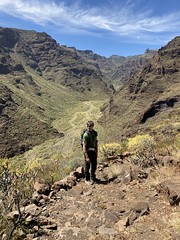
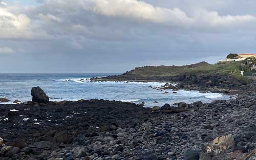
The start of the first GR 132 stage of our La Gomera hike was around 12:30 p.m. It led us from the harbor through the town of San Sebastian. The path begins inconspicuously behind the refinery, straight up and continues along the southwestern coast past the Christ Cross. We hike a few kilometers on the GR 132. Playa de La Guancha lies isolated from here further into the Barranco Juan de Vera valley. Another climb through a “desolate” terraced slope, the sun is relentless.
The black beach sparkles below
Looking back, we always saw the black beach and passed the old hamlet of Morales in the afternoon. There are some abandoned houses here. We left the GR-132 and followed the hiking trail number 28 to reach the town of Berruga at an altitude of 800 m. A particularly beautiful rest area, meadow and palm trees, unfortunately no water, but would be perfect for camping. Here we meet the road GM-3. This road leads through a valley. After 2 km of asphalt you reach the town of Vegaipala. Our overnight destination is Casa Rural La Palizada.
2: Vegaipala to La Playa (23,4 km)
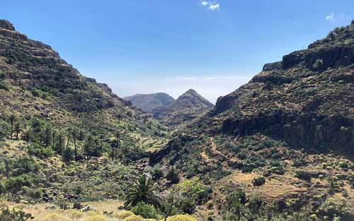
We really enjoyed this beautiful accommodation, Casa Rural La Palizada. Just behind the house the path went uphill. There were several highlights waiting for us on this second La Gomera stage. After about an hour we reached the Los Roques rock circus on a slight climb. A trademark of La Gomera is the Roque de Agando with a height of 1077 m. The Garajonay National Park begins here.
Nationalparc Garajonay
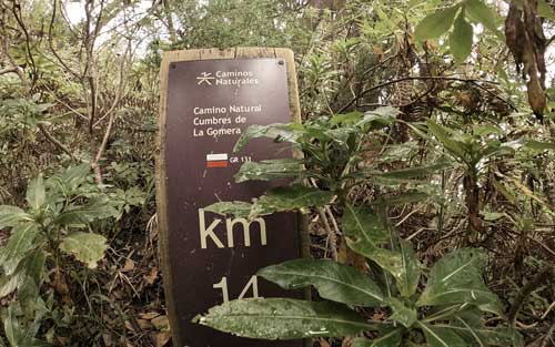
This section is one of the most popular routes on the island. We continue hiking here on the GR-131 towards the highest peak on La Gomera. This is the Alto de Garajonay with a height of 1487m. The national park is often shrouded in fog. Together with the old laurel forest, a mystical atmosphere took over us. We could hear a lot of birds. We stayed on the GR-131 towards Chipude. On our hike we soon passed through the highest village in La Gomera, Igualero. Framed by huge pines and tabaibas, there are large isolated pine trees that flow together with the magnificent landscape.
The old canal accompanies us into Valle Gran Rey
After another hour we reached Chipude. Here we were finally able to stop at a bar with a supermarket. In Chipude we left the GR 131 and followed trail number 15 to La Matanza. The so-called canal path begins here. The path runs partly inside and partly next to the old “canal” (without water). On the way we kept seeing small reservoirs (no drinking water). From here we followed the hiking trail in a southerly direction and then after a short while came to the GR-132 coastal circular route. Now we went steadily downhill through the wonderful Valle Gran Rey valley. The last steep section of the path zigzags across the terraced fields to the village of La Calera and further to the sea to La Playa.
3: La Playa to Vallehermoso (24 km)
La Playa has retained the feel of a former fishing village. A sunny harbor town with bars and cafes, along a promenade and everything is very tranquil. We had booked a comfortable, quiet apartment near the beach. In the morning we went up the plateau, which was quite a few meters in altitude. Riscos de La Merica, the well-known viewpoint and up on the plateau along the Camino La Merica with a wide view of the Atlantic. Lunch break in Arure, opportunity to stop for a break in the restaurant. There was the local specialty goat meat. From the town center, a leisurely climb along an asphalt forest road towards Las Hayas.
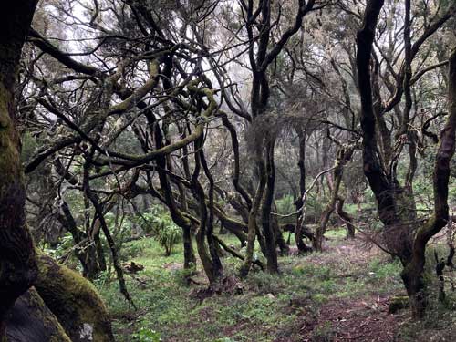
A spectacle of fog and trees
Here the GR 131 (crossing the island) took us again through the Parque Nacional de Garajonay – where we encounter an impressive spectacle of fog and forest. The high humidity creates atmospheric mist that swirls around the moss-covered trees. Shortly after crossing a street you reach the picnic area “Raso de la Bruma”. Here we hike downhill straight to Vallehermoso. The descent is steep and rocky. Shortly after leaving the laurel forest, Vallehermoso lies at our feet in the sunshine – a fantastic view. Day’s stage completed. Our accommodation sits above the center, the impressive Hotel Anaterve in Vallehermoso.
4: Vallehermoso to Agulo (16 km)
We didn’t hike to the beach in the morning, but followed the Camino, just behind the town center through old orchards, a few meters up towards Tamargada. When we reached the hill, we walked impressively along old terraced paths, past isolated houses. On this La Gomera GR-132 stage we combine the GR-132 and local paths (see map). The fresh green of the banana plants, palm trees and cacti, and the tropical vegetation in general, frame this beautiful corner of the island. The wind drives the clouds in front of it, occasionally a bright sky, which conveys peace for the soul and body. In the afternoon arrival in Agulo. Agulo is one of the most authentic villages in La Gomera.
The Feast of San Marcos
The festival of San Marcos is a very old tradition that is celebrated on April 24th and the special thing is jumping over the fire. In front of the church, along the street, a series of fires made entirely of juniper wood are arranged in a row, with some distance between them. All participants have the opportunity to skip it as a thank you to the saint, the patron saint of the community.
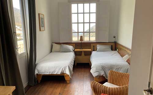
From the village of Agulo, this GR-132 stage goes steeply up to the Mirador de Abrante viewpoint, one of the highlights of La Gomera with breathtaking views. We were guests in a room in Casa Particular with breakfast on a balcony facing the Atlantic and Tenerife. Great location with a warm, friendly host who makes his own jam and listened to good music.
5: Agulo to Hermigua (17 km)
For the route to Hermigua we chose the GR-132 variant for hiking along the sea. Past huge rock faces, over terraces and the Atlantic Ocean with its washed-out black stones is within reach. Here we have the most wonderful views of the Teide. Playa de la Caleta is suitable for windsurfing and we watch the athletes and the spectacle for a while. However, you should be aware that the conditions are not for beginners. Palm trees and banana plants sway in a light breeze.
A History of the Island – Hermigua
Once we arrived Hermigua our destination is the church square. This is the origin of Hermigua, which dates back to 1598. Between the 17th and 18th centuries the monastery flourished and received donations from the richest families, but in the 19th the monastery fell into decline and was closed. The church became the property of the diocese, everything was offered for sale and became private property. Then and until the 40s of the last century the area fell into obscurity and thanks to the neighbors the church of Santo Domingo de Guzmán was consecrated as a parish church. We stayed at Casa Bayoll, it is a traditional Canarian house with history, around 400 years old.
6: Hermigua to San Sebastian (17 km)
The twin rocks of Hermigua, Pedro (the largest) and Petra (the smallest), or Roque Grande (160m) and Roque Chico (80m) – as they are also called – characterize the valley of Hermigua, especially its highest part, the Valle Alto . These emblematic symbols of nature in La Gomera are the subject of a beautiful legend in the popular imagination.
On this La Gomera stage we continue to follow the GR-132. In the morning we hike up to the Embalse Mulagua reservoir, past Las Casas and wind our way towards Paqué Natural de Majona. The path climbs steadily through the slope and we reach a nice rest area near a pine forest. Here it became sporty again until we reached the height of the ridge and ran curve after curve on the other side of the pass via Lomo Fragoso to San Sebastian. Always along the Barranco de la Villa riverbed, with the GM 1 piste road above in view, past a few towns, many kilometers on a never-ending country road. In the afternoon we reached the center of San Sebastian and booked an overnight stay in a hotel at the Plaza de la Constitucion with the former customs house.