Overview
OSM Maps
Stages/Report
Foto Gallery
Click on the symbols to get more information about the Eifelsteig stage in Germany.
Go back to parent page for our summary.
Stage report of our tour Eifelsteig, October 2020
9 Hillesheim to Geroldstein, 20km
10 Geroldstein to Daun, 24km
11 Daun to Manderscheid, 23km
12 Manderscheid to Kloster Himmerod, 18km
Read our story!
Stage 9 Hillesheim to Geroldstein, 20km
For the Eifelsteig stage 9 to 12, we had planned a total of 4 days. The starting point of the hike is Großlittgen. We found a free parking space at the church. But the infrastructure in this region is not that good and there are very few buses. We got into a taxi from the village square and drove past the Himmerod monastery to the nearby Kyllburg (20 minutes / 55 €). From there we took the regional train to Hillesheim, changing at Gerolstein.
Start in Hillesheim
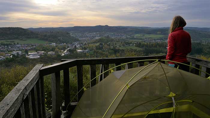
We got off at Oberbettingen Hillesheim train station, which enabled us to access the Eifelsteig long-distance hiking trail. From the Oberbettingen train station to the north, we first went uphill. When we arrived in Bolsdorf, we followed the signs for the Eifelsteig on this stage to the village of Dohm. After longer passages through the forest, we walked past the ice and millstone caves on the Rother Kopf, which are well worth seeing. With a distant view of the rolling hills of the Eifel. The late autumn day forced us to search for tents. The Schockenturm is a lookout tower and the actual stage destination Gerolstein extends below. Because we liked it so much up here, we set up camp there for the night.
Stage 10 Geroldstein to Daun, 24km
During our breakfast the weather got better and better. If you want to know what we eat on our tours, take a look at the food menu. On the Eifelsteig it first went downhill again to the Gerolstein reservoir. There we filled up our water supplies at the Seehotel, walked past a bungalow park and campsite, up to the Buchenloch cave. A little later we were able to circle the Auberg / Munterley with its mighty rocks. This spectacular rock formation is called the Gerolstein Dolomites, with rewarding vantage points.
Gerolstein
With a steep descent through serpentines it went down into the Kylltal to Gerolstein. On the other side of the Kyll River, we treated ourselves to an extensive lunch break in a pizzeria. Because the incline up to the castle Löwenburg Gerhardstein requires trained calf muscles. What followed was an idyllic stretch to the east. A cozy up and down through a wooded landscape in late summer weather. The route was partly over open terrain over plateaus, volcanic cones and valleys.

Nature parc Vulkaneifel
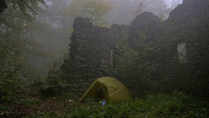
Located in the Vulkaneifel nature park, the Nerother Kopf (647m) is a recently extinct volcano. The “Freudenkoppe” castle ruin, which is now a listed building, was our night camp for that day. We found shelter from the rain under mighty beech trees in the freely accessible castle complex. One could think to have been in a fairytale forest.
Stage 11 Daun to Manderscheid, 23km
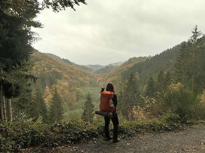
After the usual muesli breakfast, we went down from Burg Berg over the Xynthia footbridge. The Eifelsteig stage led us on this stage through a wooded landscape to Daun. The weather got better. We had lunch break in a bakery in the middle of the city. Full and happy in glorious sunshine, we went through the middle of the Daun spa park. A somewhat more demanding path led us past the Dauner Maaren, up to the Dronketurm.
Eifelmaare
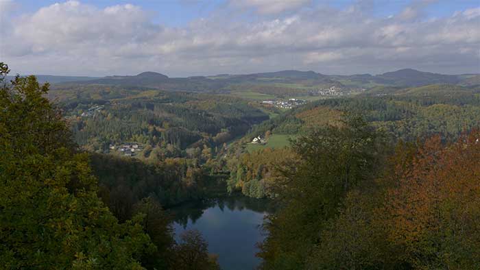
The Gemüdener Maar and the two other maars are up to 30,000 years old. In the picturesque town of Schalkmehren there are beautiful old historic half-timbered houses. From here we followed a short stretch of the country road, past the Hoher List observatory and a little later we also came through the village of Üdersdorf. From civilization we went back to the quiet Eifel landscape. Now the Eifelsteig stage ran through lonely forests and quiet valleys. Visible now and then, the Lieser is a watercourse. A sign to the forest lake appeared. The quiet lake and a beautiful hut were just the right place to stay and again protected us from the rain.
Stage 12 Manderscheid to Kloster Himmerod, 18km
Today we followed a scenic royal stage. Soon we reached the romantic Urpferdbrücke. Above the river Lieser there is a wonderful path through the colorful autumnal Liesertal. We had mixed weather, rain and sunshine alternated. We walked over footbridges and wooden bridges past incredibly diverse huts. Again and again beautiful views of the river valley opened up to us. We treated ourselves to a lunch break in a pizzeria in Manderscheid. When we pass restaurants on our tours, we often take the opportunity to get food.
Castels Manderscheid
Immediately after Manderscheid we were rewarded with an impressive view of the Manderscheid castle ruins. The Eifelsteig stage followed the Lieser river as a romantic narrow path at a height of about 100-200m. The stage in this area is absolutely fantastic, with a distant view of the mountain folds of the volcanic landscape. Over steep paths, the brown wild river always in sight, led us a short distance over meadows. Later we left the rocky Liesertal. Past fields it went over the now open hilly Eifel landscape. The Himmerod monastery was the final destination of stage 12. Due to the late return trip, we walked straight to Großlittgen and were back at the church where our car was at 6:00 pm.
Departure
Whenever possible, we park our car at the end of the hike. In other words, it means that we take the bus and train back to the starting point in advance. With this method, we avoid periods of stress shortly before the journey home and we can enjoy the hike itself more.
For more information about the Eifelsteig Trail in Germany don´t hesitate to contact us. Feel free to watch our videos on YouTube and explore our other trails we´ve experienced for you!
Take care and go out and make it happen!