Overview
OSM Maps
Stages/Report
Foto Gallery
Total climbing: 7560 m
Total descent: -9044 m
Click on the symbols to get more information about the Carnic Peace Trail in Austria.
Go back to parent page for our summary.
Stage report of our tour Carnic Peace Trail – KHW 403, August 2020
1 Sillianer Hütte to Porzehütte, 20km
2 Porzehütte to Hochweißsteinhaus, 17km
3 Hochweißsteinhaus to Wolayersee-Hütte, 15km
4 Wolayersee-Hütte to Zollerseehütte, 23km
5 Zollerseehütte to Alpenhof Plattner, 24km
6 Alpenhof Plattner to Gasthaus Starhand, 23km
Read our story!
1 Sillianer Hütte to Porzehütte, 20km
You are walking the Carnic Peace Trail in Austria the most time. Only short distances are located in Italy. The Sillianer Hütte is located on the Austrian side and is about 6km away from the Helm mountain station. When you arrive at the main ridge, the actual Carnic High Trail begins here. We stopped at the hut in the early evening with a fantastic panorama of the Sesto Dolomites. As the westernmost hut on the Carnic main ridge, the Sillianer Hütte is our starting point for the KHW 403. A wonderful place with cozy rooms and traditional dishes.
Filmoor-Standschützenhütte
After breakfast, the next day at 8 a.m. we were on the road. Past many worthwhile destinations, on the red and white marked path. The peaks Heimkeherkreuz (2273m), Hollbrucker Eck (2573m) and the war cemetery Hochgränten. In order to follow the Carnic high path you don’t necessarily have to go to the Obstansersee hut, which is a little off the beaten track (but is very comfortable). We are over the ridge to the Pfannspitze (2,678m) and towards Kinigrat. Because we have been on the road for a long time, we took a break in the Filmoor-Standschützenhütte. After another 2 hours we reached our stage destination, the Porzehütte, at around 6:00 p.m. Just in time for dinner. As in all huts, it is important to reserve sleeping places early enough.

2 Porzehütte to Hochweißsteinhaus, 17km
We started early from the Porzehütte. Summer weather was out of sight, the day began very foggy. The path up to the Tillianer Joch already looks like an old cart path, zigzagging upwards. At the top there is an interesting sign indicating that one of the main supply routes in World War I once ran here. In the further course, leisurely hiking on the ridge is the order of the day, if only the fog were finally gone. Nonetheless, we are making good progress. The short descent on the trail is tough. It goes on again on the high trail until after the Hochspitzsenke (2,314m). Secured on ropes, we climbed up to the Hochspitz. At the Steinkarspitze the view finally opens to the west, because the weather got better. Passing a rubble moraine (icy spot), after 9 hours of walking on the Carnic High Trail in Austria, we reached the rustic Hochweißsteinhaus. Despite the Corona requirements, the bed dorm was very full. The dining room was cozy and the food was excellent.

3 Hochweißsteinhaus to Wolayersee-Hütte, 15km
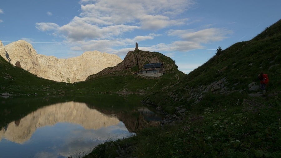
The Ofner Hoch is quickly climbed behind the Hochweißsteinhaus. The KHW 403 then leads in serpentines to an alpine pasture. Meanwhile we dive down into a forest. The descent does not end until 1550m. Another ascent, another 500m descent, a large debris field and a few hours later we took a wrong turn just before the Wolayersee hut. The only involuntary detour, we weren’t careful, were surrounded by impressive peaks. In terms of landscape and geology, the area is probably one of the most beautiful and interesting spots in the entire Alpine region. The Wolayersee Hut (1960m) is located on the lake of the same name, on an impressive rock basin. With a high mountain massage for stressed mountain hikers, we had the massage therapist Markus Hohenwarter massage our tense shoulders and legs. We didn’t have the heart to bathe in the water of the Wolayersee due to the temperature.
4 Wolayersee-Hütte to Zollerseehütte, 23km
We skipped the impressive peaks due to lack of time. From Wolayersee it went over the Valentintörl. There are some uncomfortable rubble slopes that are slowly being overgrown again. After the transition and an endless number of serpentines down, it goes to the Untere Valentins Alm. The alpine part was now behind us, now endurance was required, because the gentle mountain landscape with the extensive alpine meadows east of the Plöckenpass belong to the 2nd part of the KHW. The mountaineering village of Mauthen was not directly on the way, unfortunately we didn’t manage to do that in time. Past the closed Plöckenhaus and the Valentin reservoir we went back up to the summit. A beautiful Hochalmweg with rare orchids and a baby adder. Short break at the Köderkopf summit cross (2167m). Now the path pulled itself, a rest at the upper Bischoffs Alm and a few more meters in altitude to the Zollerseehütte. In the middle of the GeoPark Carnic Alps is the Zollerseehütte, also named after the lake of the same name. It has been completely renovated and is known for its good cuisine.

5 Zollerseehütte to Alpenhof Plattner, 24km
Today we go from the Zollnerseehütte to the Naßfeldpass, more precisely to the Alpenhotel Plattner (ski hotel). The weather is promising, according to the forecast for the morning. The long-distance hiking trail now leads us through an extremely beautiful and varied area, over gentle alpine pastures and hills. This stage has no particularly great differences in altitude and no significant alpine difficulties. Nevertheless, it should not be underestimated because of the distance to be covered. Most of the time, the path traverses extensive alpine pastures, like at the beginning of the Zollnersee, which, with the Hohe Trieb in the background, provides a particularly beautiful photo opportunity. The hike impresses with its scenic beauty and variety, but also here and there with the historical peculiarity of the region. Old fortifications from the time of the mountain war can still be seen along the way and remind us of the dark past. The Carnic Peace Trail alternates between Austria and Italy. The route ends in the large Nassfeld ski area for that day. The ski area is not nice to look at, but luckily the fantastic overall impression of the hike is not spoiled. The Alpenhof Plattner has multi-bed rooms in the basement of its hotel, regional cuisine and a rich breakfast buffet.
6 Alpenhof Plattner to Gasthaus Starhand, 23km
Despite the skiing area, behind the alpine inn you go through forests and sometimes over meadows that are still quite natural. The path to the Garntnerkofel starts directly at the mountain railways on the Sattel to the north. Then it goes over the ski slopes down to the Garnitzenalm. Shortly afterwards you are back a bit in Italy on the Traversa Carnica. On deserted paths it goes over to the Stallensattel, and then easily up and more downhill to get to the Egger Alm. Here in the region, alpine pastures are not an individual homestead, but rather a whole village. Here we took an extensive lunch break and rest. The path leads us past the picturesque Egger-Alm lake and further up and through the forest to descend to the Kesselwaldgraben, just so that we could then fight our way back to the altitude meters on the way to the Görtschacher Alm. In the late afternoon it goes up to the Starhandsattel at 1,855 m. It has started to rain again, a storm front is approaching. First over meadows and later through the forest it goes down to the Dolinza Alm (1,455 m). The Starhand guesthouse is privately run and is very rustic. Alternatively, a few meters further on the other side of the border is the Rifugio Nordio on the Italian side.

7 Dolinza Alm to St.Stefan Vorderberg (station), km
The Alpengasthof Starhand, here the boss still cooks personally. We were served a very tasty and rich dinner and the next morning a delicious breakfast. The hike to the Feistritzer Alm is short and very rewarding from here! The view of the Julian Alps is really terrific! Now it was time to say goodbye, because now it was back down to Gailal and back to the car. We left out the actual end point of the KHW, Thörl Maglern, because it was easier to get to the parked car on foot. Around noon we were at the small train station in St.Stefan Vorderberg, got into the car and were back in Osnabrück around 10:30 p.m.
For more information about the Carnic Peace Trail in Austria and Italy don´t hesitate to contact us. Feel free to watch our videos on YouTube and explore our other trails we´ve experienced for you!
Take care and go out and make it happen!