Click on the symbols to get more information about then HRP Route.
OVERVIEW HRP
HRP Route – Pyrenean Haute Route, July/August 2021
- Lescun – Forest, 11 km
- Forest – Espelunquere, 20 km
- Espelunquere – Lac Casterau, 16 km
- Lac Casterau – Refugié d‘Aremouit, 16 km
- Refugié d‘Aremouit – River Le Gave d’Arrens, 9 km
- River Le Gave d’Arrens – Refuge de Clot, 20 km
- Refuge de Clot – Garvernie, 28 km
- Garvernie – Auberge de la Munia, 18 km
- Auberge de la Munia – Refugio de Barrosa 18 km
- Refugio de Barrosa – Campingsite, 30 km
- Campingsite El Forcallo – Camping, Lac Isclots, 18 km
- Camping, Lac Isclots – Valley „Barranco de Remune“, 11 km
- Valley „Barranco de Remune“ – Hotel Hospital de Benasque, 5 km
- Hotel Hospital de Benasque – Refugi de Molieres, 14 km
- Refugi de Molieres – Refugi Restanca, 19 km
- Refugi Restanca – Salardú, 20 km
Read our story!
1: Lescun – Forest (11 km)
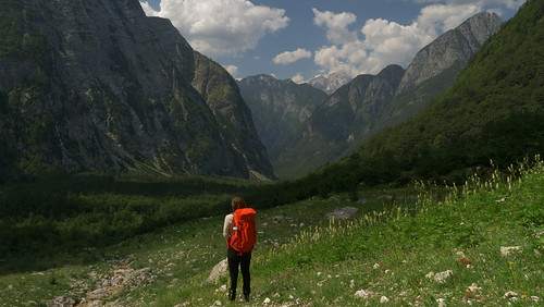
Our destination was Salardú. So we drove directly to the small Spanish mountain town of Salardú. Here we parked the car in a public free parking lot. At 7:40 a.m. the bus took us to Lea (1€). From there departure at 9:20 to Saint Gaudens (2€ to the train station). We continued at 11:20 a.m. by train to Bedous with 2 changes (30 €) and immediately afterwards by bus to Lescun (2 €). We finally got there at 3:10 p.m. Another bus took us to a junction and from here it was a 5km walk up the switchbacks to the campsite (Lescun).
Cattle were our tent neighbors
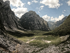
After a little refreshment, we set off around 6:00 p.m. The HRP stages are not marked and right at the beginning it took us a while to find the right path. The evening took us to the border of the national park. We pitched our tent in a sheltered area under trees.

2: Forest – Espelunquere (20 km)
Started highly motivated at 8:00 in the morning. Breakfast was in the sun at the ruins of a shepherd’s hut. This was followed by a steep climb to the Col de pau pass. The HRP follows the Grenzweg, along the slope to the Refugi d arlet. Warm food awaited us here and a spontaneous overnight stay in the dormitory. The plan was to climb to the Ibon d escantes (lake). Were unfortunately completely lost, no chance to find the path. Walk around for 4 hours without finding the way over the ridge. Weather became foggy and then we are back. We then hiked back to the sheep farm down to the Espelunquere car park, in the forest. (You can find the places to stay in the HRP map).
3: Espelunquere – Lac Casterau (16 km)
It was a rainy night so a quick breakfast of cereal and coffee. A short time later we happened to meet friendly park rangers who showed us how to get to the HRP Route again. We followed the Haute Randonnée Pyrénéenne to the so-called SanSahna car park. From here our goal was the ski area with many different paths. There was a little rest at Auberge Ayada.
Behind the hotel complex, a steep, narrow path led to the lake landscape at COL des Moines (2168 m). Arrived at the border crossing we continued to Lac Casterau. A wonderful place for our tent. Stefan went swimming. Always in view of the Pic Du medi D’Ossau (2884 m).
4: Lac Casterau – Refugié d‘Aremouit (16 km)
Around 9:30 a.m. everything packed up, then down into the valley to the river to follow a small pad up to the COL de Peyreget (2315m). At around 1 p.m. we reached the well-visited Pombie mountain hut. No lunchtime snack possible. At 2:00 p.m. we went down to the car park and behind the Caillou de Soques car park (D934 road) left again up into the forest. The second ascent of the day began. Steadily up to the COLd’Arrious (2259 m). This trail follows the National Park boundary. Arriving at the top of the pass, an imposing vulture was clearly circling.

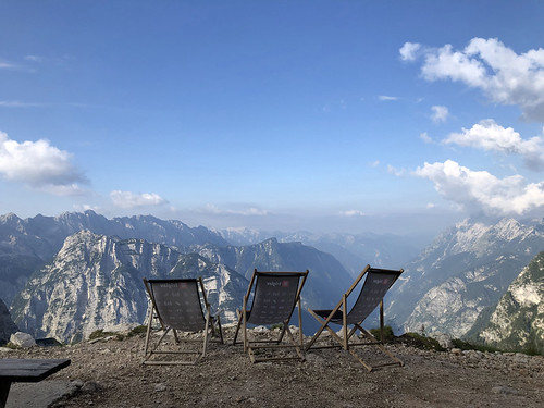
At the pass we opted for the Passage D’Orteig. It was shorter but a bit more demanding, exposed passages with steel cables. Arrived at the Refugié d’Aremouit (2305 m) in the evening around 7:30 p.m. We’re still on the HRP route. A tasty menu (€20 and camping pitch included). There is no comfort here, but very cozy.
5: Refugié d‘Aremouit – Fluss Le Gave d’Arrens (9 km)
Breakfast at the Refugié d’Aremouit for €9. We started at 9am up to the Col du Palas pass (arrival 10am). Here we briefly lost the path. This passage was extremely rocky, we saw a hiker in the jags in the middle of the mountain range. By this coincidence we guessed where to find the passage. It took forever to get there because only a few stone pyramids could be made out. Then it went down to the right bank of one of the many lakes. Again, looking at the HRP card helps.
Camping in the fog by the river
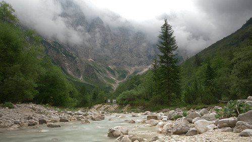
Around 3pm there was a nice treat at Refugiés Larribet: an omelette for lunch. A tip for staying overnight, shower for 3 €. Everything with a touch of art. The weather became foggy and we walked comfortably for another 2 1/2 hours through a beautiful valley with a river. A tip from a photographer to keep walking until you reach a plateau where the river flows quietly close to the path. Wonderful spot for our tent.
6: River Le Gave d’Arrens – Refuge de Clot (20 km)
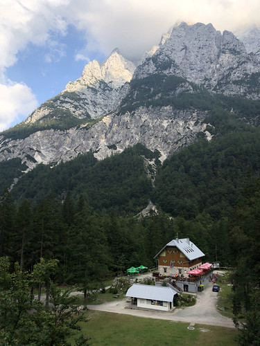
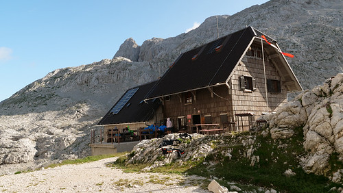
The alarm clock rang at 6 a.m. The water was boiled, there was a quick breakfast. Then we rushed off because there was a thunderstorm forecast. Around 10 a.m. we were at the top of the Cole de Cambales (2706m). The way was steep in extended long switchbacks. On the other side there was the first old snow field. The way was clearly visible. Now it was getting very rainy and around 12:30 we arrived at the Refugiés Wallon in anticipation. Super nice location, but closed. Opening at the end of 2021, everything new and big!

Due to the bad weather situation we changed our tour. We rejected the plan to cross the Cole d’Arratille 2528m & Cole de Mulets 2591m. The goal was the Refugié de Bayssellance (2651m). There was thick fog and we were glad that we had chosen the longer, safer route. We followed the river Gave du Marcadau to the Refuge de Clot (ski area). We were visibly relieved to find that the accommodation was open. Camping next door was possible. We set up our tent and booked the evening dinner. There was very delicious goulash with couscous and red wine.
7: Refuge de Clot – Garvernie, (28 km)
We walked a short distance on the GR 10. A worthwhile detour through the Valles de Gaube, past the Lac de Gaube, really beautiful. Steady uphill. At the end of the valley is the Refugiés Oulettes de Gaube (2146m). Around noon we wanted to go up to the Hourquette d’Ossoue pass (2734 m). Once at the top, we went back down to the Refugiés de Bayssellamce (2651m). Here we had omelettes again and around 2 p.m. further downhill following the river down to Vaelle d’Ossoue. Our destination for today is the tourist town of Gavarnie. Various restaurants, supermarket and an outdoor shop. We took a room at the Hotel Le Marboré (€127 including breakfast and washing machine!). Garvernie means halftime for our HRP route. A silent thank you to the two young climbers who took us along a good stretch of road.
8: Garvernie – Auberge de la Munia (18 km)
Extensive breakfast at the hotel. The first stage up to the Refugié des Espuguettes (2027 m) climbed steeply. A couple of donkeys greeted us at the mountain hut. These are used here as pack animals. The climb went on technically not difficult, but continuous. Magnificent high pasture. Arrived at 1:00 p.m. at the top of the Hourquette d’Alans (2430 m). On the other side, as shown on the HRP map, the route led into the Cabane d’Estaubé valley. A real tourist hot spot with lots of families on the river. From here there are two variants to Heas. There is a nice hostel with a small campsite (7€). The Auberge de la Munia is so beautifully French. Rooms must be booked in advance. We drank eco beer and ate crepes.

9: Auberge de la Munia – Refugio de Barrosa (18 km)
Started around 9:30 in the morning together with a stranger, we called him “Rüdiger Nehberg”. Zigzag towards Hourquette de Héas. At first we were very lonely on the road, only Rüdiger could always be seen somewhere. That changed after a good 2.5 hours at the top, we weren’t the only ones on the ridge. Behind the crest we went down to the right, along the ridge up to the second pass, Hourquette de Chermentas (2439 m). Continue marching along the rocky slopes relatively high up. It dragged on quite a bit and huge layers of stone piled up above us and we had the feeling of ending in a dead end. There was a pause just before the Lacs de Barroude. Then it went steeply up to the Port de Barroude (2534 m).
A crest of gravel and erosion formed on one side. A tundra-like plateau. Then in serpentines down to the Circo de Barrossa valley. Finally arrived for today at the Refugio de Barrosa (1745 m). A recommended self-catering hut. Kathi and Stefan (architecture students) came later. It should thunderstorm in the night. We slept well.

10: Refugio de Barrosa – Campingsite (30 km)
Quick departure and continue together with the young people. 10 km to the village of Parzan. A little tedious because you have to walk a bit along the A131 road. In Parzan we could take care of ourselves well. There is a supermarket, gas station and restaurant. Then back the piece of road, turn right onto the GR 11. Here we screwed ourselves up a forest road to the Collado Urdiceto pass (2315 m). The next destination was Viados. We made it to El Forcallo campsite (in front of Refugio Viados). This campsite was well frequented by families. There is a restaurant but no kiosk. How often does dinner need to be booked in advance.
In the evening we all discussed which route we should continue from here. On the HRP Route map it can be seen that there is the High Route or the southbound GR11 route. We decided to go the high route. Weather forecast was positive!
11: Campingsite El Forcallo – Camping, Lac Isclots (18 km)
Have breakfast in peace at the campsite. The first few kilometers were wonderful hiking along a high alpine pasture. The path forks at a small wooden bridge (river). Here at this point you make the decision high route yes or no. Next up to Port d’Aygues-Tortes (2667 m). It was real climbing, luckily the stone pyramids showed the way. It was extremely windy up there (cold), no fun staying there. Then another descent into the Vallon Aygues-Tortes. Again, that was beautiful.
Wonderful mountain lake Lac Isclots for camping
A little break at the self-catering hut Refugio Aygues-Tortes, even with dormitory upstairs. We have chosen a route above the river here. Appropriate from our perspective, because we didn’t want to go to the Refugio De la Soula. This is in the valley right next to a huge power supply line. Past a reservoir to Lac Isclots, a popular camping spot because of its beautiful location.

12: Camping, Lac Isclots – Valley “Barranco de Remune” (11 km)
Only once slept well after a stormy, starry night. That morning we were the last ones, everyone else before us had already left. Around 10:30 a.m. we were back on tour hiking. We worked our way up to the Col des Gourgs Blancs (2877 m). Here we had to cross the first old snowfields. If the weather becomes unfavorable enormous difficulties could arise. Navigating, sure-footedness and exhaustion then become a real problem! A challenging terrain! We reached Tusse de Montarque (2989 m). From there in the back and forth “wild west” orientation to the Refuge du Portillon. This is a spacious large Refugiés with a good menu selection. Reservations are always an advantage. We had an enjoyable time.
Old snow fields or a slippery gravel slope
Are then around 16:00 along the reservoir wall up to the Col Inferieur de Literole (2983 m). Due to the unclear route and the remaining snow areas, we had to decide whether to take the gravel slope or the ice field. Due to shallows and crevasses, we chose the very sloping gravel slope. An extremely slippery and not without danger affair. That was a tough time.

At the top of the Bergscharte we came down steeply again. An impressive plateau with turquoise ice lakes and old ice, and no vegetation. Here we then switched to Komoot because a suitable path led us out well. Down from the plateau into the basin where the valley begins or ends. Barranco de Remune is the name of the river that formed the valley. There we prepared two dinner bags around 9:00 p.m., exhausted but satisfied with the last drop of gas.
13: Valley “Barranco de Remune” – Hotel Hospital de Benasque (5 km)
Started around 9:30 a.m., a slightly cloudy morning. The night was comfortable and we had a good feeling. Followed the Vall de Remune valley. Always along the river with a decent gradient. The kilometers to the parking lot dragged on. 13:00 Arrival at Hotel Hospital de Benasque. We called spontaneously and actually got a room (€144 including half board). Quick check in then bus to Benasque 30 minutes (6.50€). Did a little shopping spree, a place where you can get everything. We thoroughly enjoyed the hotel!

14: Hotel Hospital de Benasque – Refugi de Molieres (14 km)
After the mega breakfast, a shuttle bus (departs near the hotel) took us to La Besurta. With many other day hikers we walked that morning until just before the junction of the Col de Toro. We then continue to follow the HRP route up to the Tuc de Molieres (3009 m). When we thought we were at the top, a very long, smooth rock plateau came as a surprise. Attention, here you actually have to head for the summit, more to the left than straight ahead. Corrected our mistake and descended from the summit 500m north on the other side. There WE met the Berlin girls Ada & Yaara again.

This is one of the HRP stages where good orientation (maps) becomes important. Because it was really not easy to find the transition and descent. Very steep terrain, therefore partly climbed backwards down into the Vall de Molieres valley. Shortly before the Refugi de Molieres we used an existing bivouac site for our tent at around 6:00 p.m. on the first, uppermost lake. The evening sun was gorgeous.
15: Refugi de Molieres – Refugi Restanca (19 km)
Windy but rainless night. After a leisurely breakfast we descended along the river through Vall de Molieres past impressive water cascades and beautiful scenery. This variant of the GR11.5 leads to a parking lot where hikers can get back on the GR11. This place is above the road to the car tunnel entrance. From the parking lot we made a small detour to the Refugi de Conangles. Maximum 20 minutes detour, but recommended for a lunch break. Back at the starting point, the GR11 took us east to Port de Rius (2344 m)
Then the next highlight was waiting for us at the top, the Lac d’Arrius. Like out of a picture book! Behind this lake you have to make a decision. Continue to follow the HRP to bypass the Tossau de Mar mountain peak or follow the no less long part of the GR11. Because it was quite late for us (6:00 p.m.), we hiked directly to the Refugi Restanca on the GR11. We stayed there and got two beds for ourselves in a shared room (€22 and €8 for dinner tabulé, €3.50 beer)
16: Refugi Restanca – Salardu (20 km)
Today is the last day of hiking, the goal of the day was our end point, the mountain town of Salardu. Started at 8:30am and straight up, the final climb to Port de Caldes (2567m). Around 1:00 p.m. we reached the Refugio Colomèrs, short break. From here the trail is very boring. The last few kilometers were challenging for us, as only gravel roads and tar roads up to the center of the small town. Arrived at the final destination around 4:30 p.m.!!!
Super happy and grateful to have completed the HRP stages after 16 hiking days and 273 kilometers. Grateful for all the help, nice encounters and exciting experiences. As always, happy that no injuries occurred.
For more information about the HRP Route and the stages in Spain and France, don´t hesitate to contact us. Feel free to watch our videos on YouTube and explore our other trails we´ve experienced for you!
Take care and go out and make it happen!