Summery
Maps
Stages
Gallery
Video
Total climbing: 5154 m
Total descent: -5155 m
Torres del Paine Guide O Circuit, Map GPX-File-Download
(with locations of overnight stays)
The use of the data is only permitted for private use and is at your own risk. The data is for rough guidance only. No liability is accepted for errors or inaccuracies. Passing on to third parties or publishing the data is not permitted.
Arrival and Registration
Using our Torres del Paine Guide & Map, you’ll discover that Puerto Natales is the gateway for most hikers. The city is easy to explore on foot and the proximity to the national park makes it easy to get there by bus. Various bus companies travel to the Torres del Paine National Park at regular intervals. It is strongly recommended to book online in advance. This is especially true for the early tours. A trip with Bus Sur costs 14,000 CLP. You´ll find more information about “what to do” at Torres del paine on the Touristic Portal website.
Registering at the entrance to the national park (Laguna Amarga) is relatively easy. Since we are staying in Torres del Paine for more than 3 days, you pay 44,500 CLP. You buy the tickets for Torres del Paine on the pasesparques.cl website. We get off and the barcode is scanned on site and then the journey continues for us with the shuttle bus (4500 CLP). An alternative is to run these 6 km. For the W-Trek you get off in Pudeto. The popular Salto Grande viewpoint is also located there.

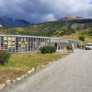
The shuttle bus takes us to the Torres del Paine Welcome Center. Here you have the opportunity to buy snacks and drinks again. We finally want to leave! After 2 days of travelling by plane and bus, we are longing for wild, untouched nature! The hiking trail starts directly behind the center.
Explore more hikes
What are you waiting for? Get your hiking boots on and let’s go!
Torres del Paine O Circuit (W Trek) – Guide 2025
- Welcome Center – Camping Seron, (13 km)
- Camping Seron – Camping Dickson (18 km)
- Camping Dickson – Camping Los Perros (12 km)
- Camping Los Perros – (John Garner Pass) – Refugio Grey (15 km)
- Refugio Grey – Camping Paine Grande (11 km)
- Camping Paine Grande – (Valle Francés) – Camping Cuernos (23 km)
- Camping Cuernos – Camping Central – (Towers) (33 km)
Trekking the O Trek (include W Trek)
1: Welcome Center – Camping Seron, (13 km)
Getting started on the adventure – Torres del Paine Trek Guide & Map
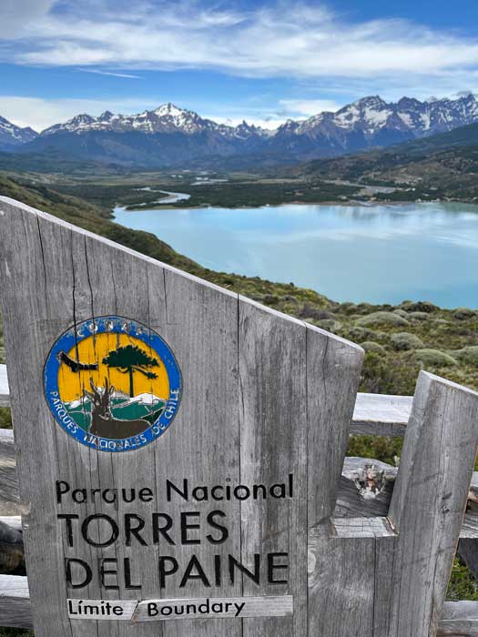
The O-Circuit in Torres del Paine National Park begins with clear signage showing us the way. Right from the start, it is clear that the hiking trails here are excellently marked and there are no difficulties in finding the starting point. We start our first stage of the O-Trail on well-maintained paths that lead through forests and meadows and cross a gently rolling landscape.
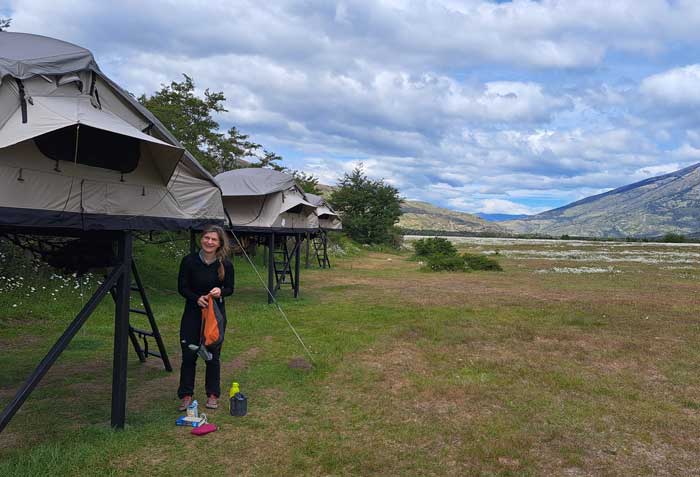
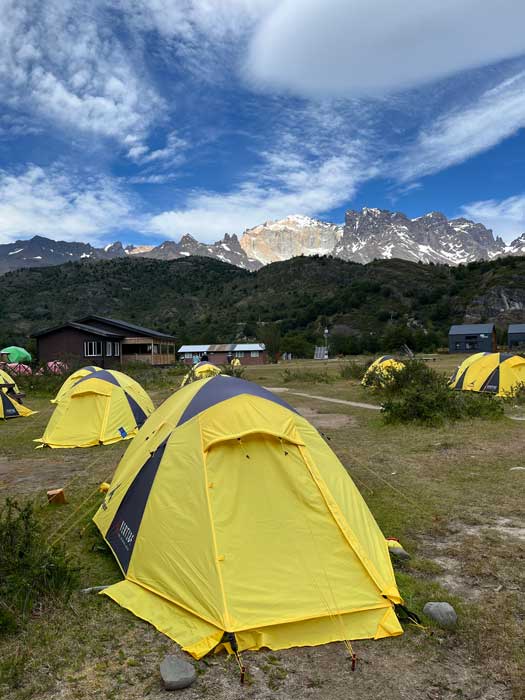
This route is easy to walk and prepares us well for the more challenging sections of the coming days. While we enjoy the rhythmic pace on the trail, we get used to the weight on our backs. After about 13 kilometers and about four hours of hiking, we reach the idyllic Serón camp. Before we can rest, we complete the registration formalities in the main building and find out where to find our premium tent. We are given meal times for dinner and breakfast because we have booked the catering. Alternatively, you can prepare your own food in a communal tent.
On Christmas Eve we enjoy a wonderful dinner in the premium tent with full board and celebrate with our new companions Katy, Candy and Michael. A bottle of wine costs €18, but the festive feeling is priceless. Camp Serón offers reasonably clean wet rooms with hot showers, although these are solar powered and can occasionally stay cold.
2: Camping Seron – Camping Dickson (18 km)
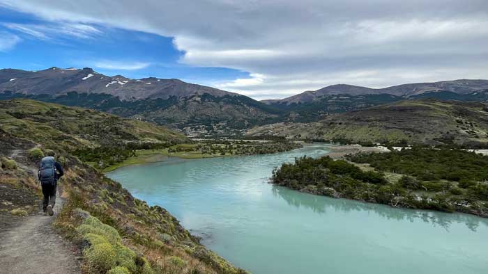
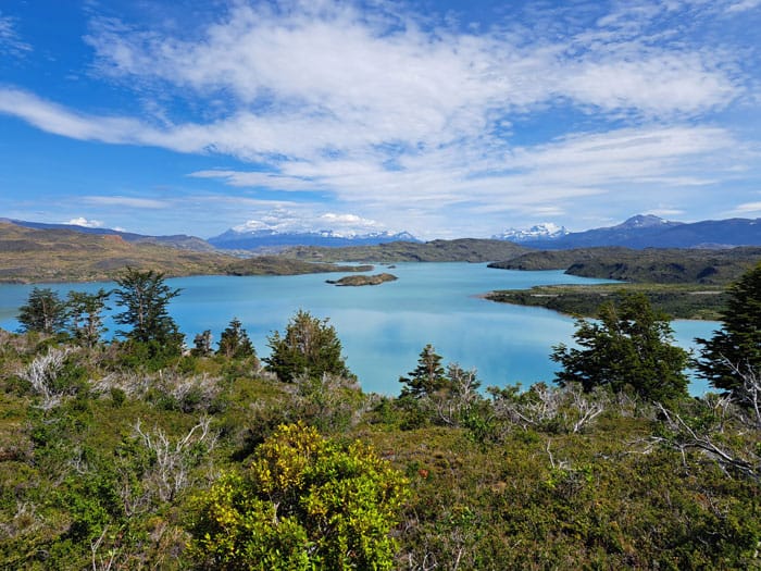
On the second day of our hike, the stage from Serón to Dickson takes us along the Paine River. The route mostly runs through a dry landscape with blooming camille that looks like snow fields. We enjoy the easy hike past Lago Paine and the imposing peaks. This stage of the O-Trek is not only one of the longest, but also one of the most beautiful in the entire “Torres del Paine O Circuit”. A special section of the stage takes us over a windy pass in the area of Lake Paine. About halfway through we pass the Coirón ranger post, where you have to prove your reservation and register. On this day no ranger is at this site. There are toilets, a picnic area and the opportunity to fill up with water.
Shortly before we arrive at Camp Dickson, we get a great view of the accommodation and the surrounding landscape from a hill – the perfect place for a photo. We hike about 19 kilometers on beautiful paths until we reach the breathtakingly located Refugio Dickson on the lake of the same name. The refugio is located on a peninsula, surrounded by mighty glaciers and rugged mountains. After a short, steep descent, we reach the Dickson ranger station and register again before continuing to the campsite.
Once we arrive at Check In Camp Dickson, we get our tent number. We sleep in a classic two-person rental tent with a mattress. We cook for ourselves and use the cooking room with a sink and seating. You could book your meals in advance of course if you like. The showers are warm and the washrooms are well designed, with mirrors and sinks outside the toilet cubicles. There is also a small shop with snacks and other small items.
3: Camping Dickson – Camping Los Perros (12 km)
On the third day there is a short stage ahead, for which we plan around four hours. After a leisurely breakfast we set off and enjoy the idyllic location of the Refugio Dickson for a while before we start. The first part of the hike to Campamento Los Perros leads steadily uphill through old forest in which the tree species Nothofagus Antártica grow. On the way we discover wild orchids and ferns. After about a third of the way we reach the Valle Los Perros viewpoint, which offers a wonderful view of the valley and the glacier of the same name. We continue on forest paths over and along the Los Perros river. Since this contains a lot of sediment, it is not suitable for filling up our water bottles.
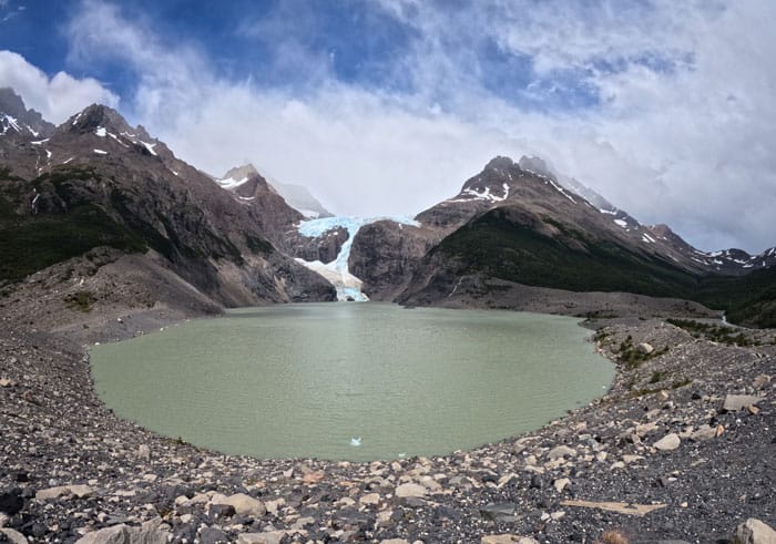
Shortly before the campsite we make a detour to Laguna Los Perros and continue along the scree slope where we can see the glacier up close. In the camp, registration takes place with the ranger and check-in takes place in the camp itself. Camp Los Perros is located nearby in the forest and the infrastructure is rudimentary. There is only cold water for showering, and here too, gas can only be used in the cooking room. The service is good, however, and the route guidance on the O Circuit has been great so far, so you can’t get lost. With our “Torres del Paine Trek Guide & Map” article you have all the necessary information. This campsite is the simplest accommodation on our hike. The showers are ice cold and the space is limited. We also meet some solo travelers and enjoy the exchange. Electricity is free, but there is no network reception. Wifi costs 10 euros per hour and there are enough sockets.
4: Camping Los Perros – (John Garner Pass) – Refugio Grey (15 km)
On the fourth day, we will be facing the longest and most strenuous stage of the O-Trek in Torres del Paine National Park. We will start this king stage early, as the trail will be closed by the rangers in the afternoon. In very bad weather conditions, the rangers will not allow us to cross the John Garner Pass. Fog and extreme wind can then be life-threatening. The path initially takes us uphill for a good hour through dense forest, which is often muddy and rooty. Then we reach the forest-free zone and see the Dana Pass in the distance. For many months of the year, this pass is covered in snow, and even in summer there are still a few old snowfields. Fortunately, today we have bright sunshine and no wind.

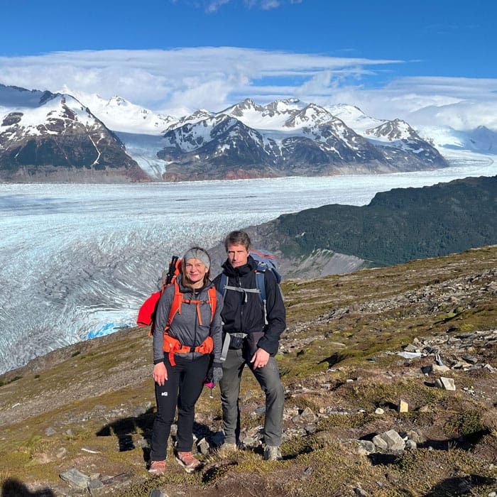
As soon as we reach the John Garner Pass at around 1,200 meters above sea level, we are treated to a breathtaking view of the Grey Glacier. This view is one of the most beautiful on the entire hike and rewards us for the strenuous climb. Now the long descent towards Camping Grey begins. The trail leads us through the forest again, often over steep terrain and along long suspension bridges, which require a head for heights. During the descent, we increasingly encounter hikers who are climbing from Grey to the glacier. Up to John Garner Pass, the trail can only be walked counterclockwise, which keeps the trail clear and organized. As soon as we start descending, other hikers come towards us, which can be annoying in narrow sections of the trail.
About halfway, we pass the Paso campsite, which is currently closed but still serves as a landmark. Here we register again and use the toilets before continuing our descent. On this section, we also cross the famous suspension bridges with the glacier in the background. After about five hours of descent, we finally reach the Grey station, which is much busier than the previous stations. The Refugio Grey is well equipped and offers a high level of comfort. There are warm showers, comfortable lounges and a small shop with snacks and other small items. We quickly notice that there are already significantly more hikers here, as Grey is also part of the shorter W trek.

In the evening we end the day with local beer and our companions while we enjoy the impressive view of the Grey Glacier. This stage is strenuous, but the breathtaking views and the varied landscape make it an unforgettable experience. Our “Torres del Paine Trek Map” is of course available for download as always.
5: Refugio Grey – Camping Paine Grande (11 km)


On the fifth day, a comparatively easy but very scenic section awaits us. The stage is indicated as about ten and a half kilometers, so we take it easy. After a leisurely breakfast with muesli and coffee, we start our walk.
The first few meters lead us through a romantic little gorge, where we cross a few streams. After that, we reach an open landscape without shade, which repeatedly offers wonderful views of the Grey Glacier glittering in the distance.
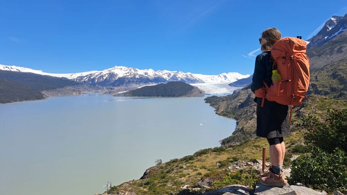
The hiking trail runs along Lago Grey and is not particularly difficult. In total, we need about four hours if we walk leisurely and take a short break at the viewpoint over the Grey Glacier. The path climbs at the beginning and then descends towards the end to the Paine Grande station. The check-in for our campsite reservation takes place in a room at the main building. As often emphasized in our “Torres del Paine Trek Guide & Map” article, registration and check-in are well organized in our experience.
Camping Paine Grande looks very luxurious and is well equipped. This is also where the catamaran docks, which explains why so many day trippers start here and do their hikes in both directions. This is also an alternative entry point for the W-Trek if you want to walk it anti-clockwise. In the evening we relax on the shore of the lake, although swimming is strictly prohibited. Overall, this is a wonderful and relaxing section.
6: Camping Paine Grande – (Valle Francés) – Camping Cuernos (23 km)
Our destination for the sixth stage is Camping Cuernos, a 23-kilometer route with breathtaking views and challenges. We start our hike in beautiful weather. Claudia and I enjoy the silence of nature. Soon after, I walk ahead and choose the left path towards Valle Frances. The first 7.5 kilometers of this stage run comfortably along Lago Skottsberg. Here I meet Michael, who tells me that Claudia is far behind us.
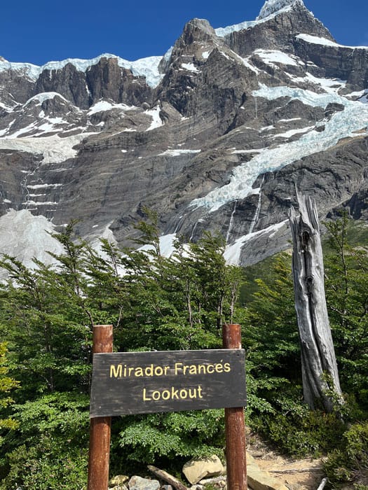
I reach Campamento Italiano and wait there with Katy and Candy. When everyone finally arrives there, we leave our backpacks at the hut and start into Valle Frances. The climb to Mirador Brittanico is technically easy but strenuous. We cross forest-free sections with spectacular views of the Patagonian mountains. The sun is shining and we enjoy the moment before we start the descent. This is about 2.5 kilometers one-way according to official information.
The way back takes us along the river to Lago Nordenskjöld. The turquoise blue water is more reminiscent of the Mediterranean than a subarctic lake. After about 6.5 kilometers we reach Camp Cuernos, where our premium tent is prepared. The Refugio Los Cuernos is one of our favorite camps in the park. This stage has an elevation gain of about 900 meters.
7: Camping Cuernos – Camping Central – (Towers) (33 km)
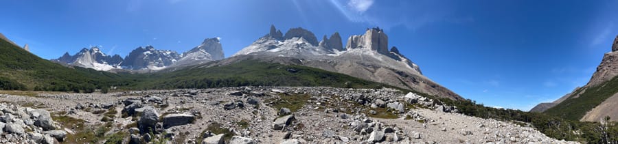
On the seventh day, the stage takes us to Camping Central, a distance of about 14.5 kilometers if you have stayed at Refugio Cuernos. Hikers who have stayed at Camping Frances have to cover about 4.5 kilometers more. This stage is not forested and offers us a lot of variety as well as impressive views along the turquoise Lago Nordenskjöld.
After about two thirds of the way, we come to a crossroads where we turn left towards Refugio Chileno and straight on into Sector Central. From here it is about 2 to 2.5 hours. The landscape changes, the path leads over meadows and small forests to the “Paso de los vientos” – the windy pass that lives up to its name. On windy days you have to expect strong gusts.
Today it is cloudy and a little reminiscent of the Scottish Highlands. We keep coming across hikers who are doing the W Trek or going on a day trip. Guided groups can also be seen, although in our opinion the path is clear and without dangerous sections. An exception can be the John Garner Pass in bad weather and with little hiking experience. In our Torres del Paine Trek Guide and the map you can see that the path is easy to follow.
In the early afternoon we reach Camping Central. The small “reception” is still closed, so we make ourselves a coffee. The Refugio Central is a few hundred meters away and offers food. The hours of doing nothing fly by, and we are all looking forward to the Torres del Paine towers the next morning. The weather forecast is not so bad, so we set our alarm for 2:30 am.
Hike to the Torres del Paine towers

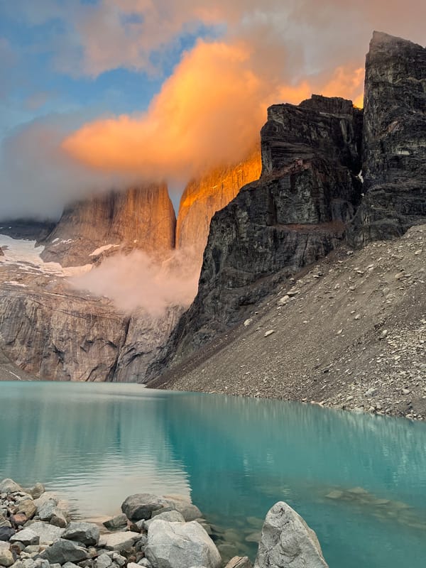
The hike to the base of the Torres del Paine is the highlight of our tour. With headlamps and warm gear, we start at camping central, passing the Hotel Las Torres. In the dark, we see other hikers. The path leads steeply through the forest and the last section over rocks to the Base de las Torres. The view of the three gigantic rock towers in front of the blue lagoon makes up for the climb. The sunrise is particularly magical, when the first rays of sun bathe the granite rocks in magical light at 5.30 am. We are excited and grateful that it is not raining.
After half an hour of enjoyment, the cold makes itself felt and we decide to descend. During the two hours back to Camping Central, we meet many other hikers coming up. The path is closed from 6 p.m., which makes a hike at sunset difficult.
Back at the tent, we pack our things and go to the Welcome Center, which is only a few meters away. We are overjoyed to have made this fantastic trekking tour and would like to thank everyone who gave us wonderful moments!


